

Greenland Mines Delivers Two Key Milestones at Skaergaard: Bathymetric Survey Completed, Initial Metallurgical Core Drilling Concluded
Survey vessel M/V Byr returns safely to Iceland having covered more area with water depth data (bathymetry) than originally planned
High-resolution seabed data already used to safely anchor support vessel Argus within 500 meters of the western outcropping mineralized zone at Skaergaard
Data advancing toward official navigational charting and future shipping infrastructure planning for the Project's next development phase
Initial HQ drill core supporting the metallurgical bulk sample successfully completed, with the program shifting to NQ-size core drilling from a newly established, fully operational core shack
SKAERGAARD, Greenland, Aug. 17, 2026 (GLOBE NEWSWIRE) -- via IBN – Greenland Mines Ltd ("Greenland Mines" or the "Company") (Nasdaq: GRML) is pleased to announce the successful completion of its 2026 bathymetric survey campaign at the Skaergaard Project in southeast Greenland, carried out by Icelandic Lagenes ehf using the expedition, research and survey vessel M/V Byr.
The vessel has returned safely to Iceland having covered more survey area than originally planned, with the acquired data verified and confirmed to meet the high-resolution technical specifications required under the survey contract.
M/V Byr, from Icelandic Lagenes ehf, was operated under the command of Sigurdur Jonsson, who has navigated the fjords of East Greenland for the past 25 years, and covered navigation route surveys and full multibeam coverage across Mikis Fjord, J.C. Jacobsen Fjord, Skaergaard Bugt and Uttendal Sund. Onboard the survey acquisition was overlooked by Survey Chief and Survey Engineer Lauri Aakko.
The value of this new dataset has already been demonstrated in practice: High-resolution bathymetric data was used to safely guide the Company's support and operations vessel Argus to a new anchorage in Uttendal Sund, just 500 meters from the main initial operational area for the 2026 field season, located in the western part of the outcropping gold, palladium and platinum mineralized zone at Skaergaard.
"This is precisely the kind of foundational work that turns a promising deposit into a developable project," said Dr. Bo Moller Stensgaard, president of Greenland Mines Ltd. "For the first time, we now have high-quality seabed data across the fjords surrounding Skaergaard, acquired to international survey standards and already put to direct operational use this season.
“This survey will help enable the Danish Geodata Agency to produce new, official navigational charts for the Skaergaard fjord system. In parallel, we will use the data to commission a dedicated navigational safety study for the Company, and it will underpin the infrastructure planning required for future large-scale shipping operations at Skaergaard, covering both the construction and, ultimately, the production phases of the project. This is a major stepping stone toward the next phase of Skaergaard's development.
"At the same time, our drill campaign continues to build momentum. All HQ-diameter drill core supporting our planned metallurgical bulk sample has now been completed successfully by our contractor Nordisk Fundering A/S, and the program has shifted into NQ-size core drilling, supported by a newly constructed and fully operational core shack facility on site."
Marine Survey: Scope, Results and Strategic Value
- Survey scope exceeded: The campaign, conducted using multibeam bathymetric system aboard M/V Byr, covered more survey area than originally planned under the charter, providing broader data coverage across Skaergaard's approach fjords than initially scoped.
- Data quality confirmed: Acquired bathymetric data has been reviewed and confirmed to meet the high-resolution technical specifications required under the survey contract, providing the Company with a reliable, high-confidence dataset.
- Immediate operational value: Data was used to identify and safely execute a new anchorage for support vessel Argus in Uttendal Sund, within 500 meters of the western outcropping mineralized zone that is the focus of the 2026 field season's initial drilling and bulk sampling activity.
- Supporting official navigational charts: Survey results are now undergoing further review and validation and are expected to support and inform the official production of new navigational charts for the Skaergaard fjord system by the Danish Geodata Agency (“Geodatastryrelsen” – GST). The Company will also commission a dedicated navigational safety study based on the survey findings.
- Foundation for future shipping infrastructure: This is the first time comprehensive seabed mapping data has been acquired across the fjords surrounding Skaergaard, providing a foundation to support planning for the large-scale marine shipping operations that will be required for both future construction and, ultimately, production activities at the Project.
Drill Program Update: Metallurgical Core Complete, Program Shifts to NQ
In parallel with the marine survey campaign, the Company's 2026 drill program has reached an important milestone, with all HQ-diameter drill core required to support the planned multiton metallurgical bulk sample now successfully recovered by the contractor Nordisk Fundering A/S. Having completed this phase, the drill program has transitioned to NQ-size core drilling, the standard core diameter used for the resource definition and geotechnical drilling that will continue through the remainder of the season. A newly raised core shack facility, providing dedicated space for core logging, sampling and storage, has been completed and is now fully operational on site.
A Season Delivering on Multiple Fronts
Together, the successful completion of the marine survey campaign and the advancement of the drill program illustrate the breadth of the Company's 2026 field season at Skaergaard, which spans resource definition drilling, metallurgical bulk sampling, environmental baseline studies, and the marine and infrastructure data required to support the Project's advancement toward an Initial Assessment and its next phase of development.
About the Skaergaard Project
Skaergaard is one of the world's largest undeveloped palladium, gold and platinum deposits, hosted in the Triple Group of the Skaergaard layered mafic igneous intrusion in southeast Greenland, approximately 400 km west of Iceland. The deposit benefits from deep fjord access and proximity to the existing Sødalen airstrip. Greenland Mines, through its subsidiary Major Precious Greenland A/S, holds an 80% interest in and option to acquire the remaining 20% of the three Mineral Exploration Licenses covering the Project and adjacent areas.
Skaergaard's location on Greenland's east coast is central to the Company's long-term vision for a North Atlantic Critical Metals Corridor, anchored by upstream production at Skaergaard and potential downstream processing and logistics infrastructure in Iceland. In support of this vision, Greenland Mines holds a First Right of Refusal on the Helguvik industrial complex on Iceland's Reykjanes Peninsula, a brownfield site with existing industrial infrastructure, deep-water port access and low-cost renewable grid power, located approximately 400 km by sea from Skaergaard.
About Greenland Mines Ltd
Greenland Mines Ltd is a Nasdaq-listed company with two operating divisions: (1) Mining, focused on the exploration and development of the Skaergaard Project in southeast Greenland and, subject to closing of the previously announced transaction, the Sarfartoq neodymium-praseodymium (Nd-Pr) rare earths project in southwest Greenland; and (2) Biotech, including Klotho's KLTO‑202 primary indication for ALS. The Company’s strategy is centered on building a multi-asset platform with exposure to rare earth magnet materials, precious metals, and select midstream processing opportunities, while advancing its broader North Atlantic Critical Metals Corridor vision linking Greenland resources with allied downstream jurisdictions and industrial infrastructure.
Forward-Looking Statements
This press release contains forward‑looking statements within the meaning of the U.S. Private Securities Litigation Reform Act of 1995. Forward‑looking statements are often identified by words such as “believe,” “expect,” “anticipate,” “intend,” “plan,” “potential,” “could,” “may,” “will,” “should,” “estimate” and similar expressions. These forward-looking statements include, but are not limited to, statements regarding the intended use, validation and further processing of the bathymetric survey data; the anticipated production of navigational charts by relevant authorities; the Company's plans to commission a navigational safety study; the potential role of the survey data in supporting future shipping and infrastructure planning for construction and production at Skaergaard; the scope, timing and results of the 2026 drill program, including the transition to NQ-size core drilling; and the Company's plans to advance Skaergaard toward an Initial Assessment and its next phase of development. These statements involve known and unknown risks and uncertainties, including weather, logistical, permitting, regulatory and operational risks inherent to Arctic marine survey and field programs, that could cause actual results to differ materially from those expressed or implied. Mineral Resources are not Mineral Reserves and do not have demonstrated economic viability. Readers should not place undue reliance on forward-looking statements. The Company undertakes no obligation to update any forward-looking statement except as required by applicable law.
For further information:
Investor Relations
Greenland Mines Ltd | Nasdaq: GRML
Email: ir@greenlandmines.com
Website: www.greenlandmines.com
InvestorWire Service Contact:
IBN.Ai
Austin, Texas
www.IBN.ai
512.354.7000 Office
Editor@IBN.Ai
Attachments
- Skaergaard 2026 Campaign Map
- Fully Operational Core Shack
- HQ Core Logging
- XRF Measurements Conducted
- Greenland Mines Survey Work


Skaergaard 2026 Campaign Map
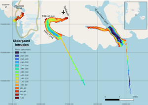
The bathymetry data surveyed during the Skaergaard 2026 campaign with outline of the Skaergaard Intrusion that hosts the Gold, Palladium and Platinum mineralization. The gravel air strip at Sødalen is also indicated. The coastal part near Mikis Hus in Mikis Fjord is considered one of the prime locations for future infrastructure for a mining operation at Skaergaard. IC Jacobsen Fjord is surveyed for its potential for a secondary safe anchoring site for larger vessels.
Fully Operational Core Shack
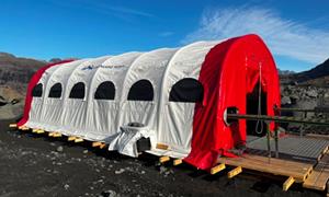
Greenland Mines' newly established core shack facilities at Skaergaard.
HQ Core Logging
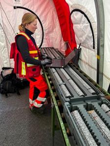
Greenland Mines Ltd. geologists doing HQ core logging from the mineralized Triple Group within the Skaergaard Gold, Palladium and Platinum deposit.
XRF Measurements Conducted
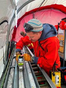
Greenland Mines Ltd. geologist doing handheld XRF measurements used for identifying the geochemical signature that can be used for mapping the geological units within the Triple Group from which the location of the Gold, Palladium and Platinum mineralized zones can be determined.
Greenland Mines Survey Work
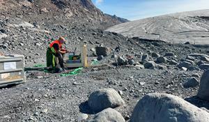
Down-hole surveying conducted by the geophysical contractor Vanguard Geophysics on HQ holes beneath the Forbindelsesgletscher and beneath the cliff face that host the surface outcropping Gold, Palladium and Platinum mineralized zones of within the Triple Group within the Skaergaard Intrusion.
Legal Disclaimer:
EIN Presswire provides this news content "as is" without warranty of any kind. We do not accept any responsibility or liability for the accuracy, content, images, videos, licenses, completeness, legality, or reliability of the information contained in this article. If you have any complaints or copyright issues related to this article, kindly contact the author above.
